Research Resources : Library of Google Earth Files
|
|
|
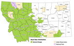
These data represent black bear species distribution. At their most detailed, they depict species occurrence at a one square mile Section level. Black Bear Distribution Download
|
|
| ||
|
|
|
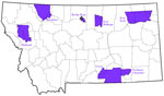
These data represent the Montana Indian Reservations digitized from 1:250,000 scale USGS maps. |
|
| ||
|
|
|
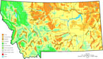
Major land uses in Montana from the National Atlas of the United States, (1970) for the purpose of displaying and analyzing small-scale land use patterns. |
|
| ||
|
|
|
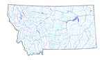
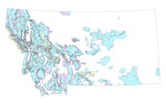
Steams and lakes selected from 1:100,000 scale US Census Bureau TIGER files. Selected to approximately match data shown in USGS 1:2,000,000 scale DLG files. Names are mostly from TIGER, also from Montana DOT county maps and USGS quads. |
|
| ||
|
|
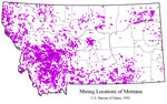
Mine locations from the U.S. Bureau of Mines Mineral Information Location System (MILS) database. Montana Mine Locations Download | |
|
| ||
|
|
|
This map layer represents limiting factors for elk in the state of Montana. Issues which presently or in the near term (3-5 years) may effect elk habitat and elk management at landscape and/or herd unit levels. |
|
| ||
|
|
|
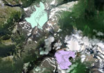
This map layer represents four glaciers of Glacier National Park and how they have changed over time. This dataset extends from 1850 to 1993. |